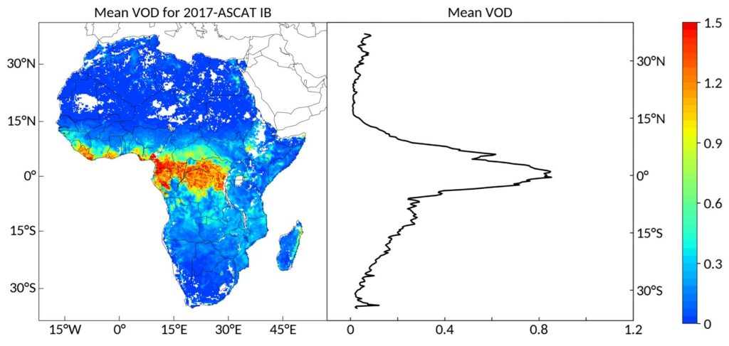
ASCAT IB VOD was developed by the INRAE-Bordeaux (IB) Remote Sensing Lab (Liu et al., 2021, in review). ASCAT IB VOD is the active C-band vegetation optical depth (C-VOD) retrieved from ASCAT at a resolution of 25 x 25 km. The data was retrieved based on the Water Cloud Model (WCM) coupled with the Ulaby linear model.
Key Features: ASCAT IB VOD is independent of passive microwave observations. The main features of IB VOD are that (i) the ERA5-Land soil moisture (SM) dataset was used as an auxiliary SM dataset in the retrievals, (ii) pixel-based soil model parameters were mapped using Random Forest (RF), and (iii) the vegetation model parameter was calibrated for each day.
Product: ASCAT IB VOD provides 5-years (2015-2019) daily descending (overpass at 09:30 a.m. Local Solar Time) VOD in the NetCDF format with the WGS84 project. The global product is ongoing.
Reference: Liu, X. Wigneron J.-P., et al., ASCAT IB: A radar-based vegetation optical depth retrieved from the ASCAT scatterometer satellite, Remote Sensing of Environment, in review.
Naming convention:
METOPA+ASCAT_IB_VOD_M_C_DOY_2015001.nc
METOPA: The Advanced SCATterometer (ASCAT) were carried by three satellites (MetOp-A, MetOp-B and MetOp-C). METOPA means the backscatter from MetOp-A were used to retrieve the VOD.
ASCAT: Advanced SCATterometer. The name of sensor.
IB: INRAE-Bordeaux. The name of product.
VOD: Vegetation Optical Depth.
M: Morning (Descending).
C: C-band.
DOY: Day of year.
2015001: Tag for the day 4 digit year and 3 digit doy.
Data Format:
All data are saved in ‘netcdf4’ format as 64-bit DOUBLE point numbers in NetCDF format. Each file contains a 720 by 1440 entry map.
lat: latitude (°)
lon: longitude (°)
vod1: original daily vod
vod2: smoothed daily vod with moving window 21 days
vod3: original daily vod with moving outliers
Questions?
Email jean-pierre.wigneron@inrae.fr or xiangzhuo.liu@inrae.fr